Satellite technologies are transforming the way disasters are anticipated, monitored, and managed. From mapping floodwaters to tracking wildfires and assessing damaged infrastructure, Earth Observation (EO) provides critical information across the disaster management cycle. Yet the availability of satellite data is only part of the equation. Its value ultimately depends on whether that information can reach decision-makers in time to support effective action.
As climate-related hazards put growing pressure on communities and essential services, integrating space-based information into prevention, preparedness, response, and recovery is becoming increasingly important. The challenge is not simply to observe more, but to make satellite intelligence accessible, actionable, and embedded in operational processes.
Space technologies contribute across the entire disaster cycle
Disaster management is a continuous process rather than a single emergency response. Satellite capabilities contribute at each stage, with different requirements for timeliness, accuracy, and coordination.
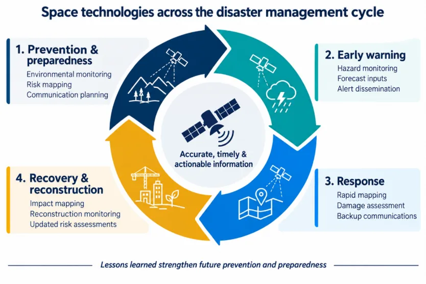
Space technologies across the disaster management cycle. Source: original Novaspace contributor graphic.
Before a disaster, remote sensing and modeling help identify environmental changes, assess exposure, and support preparedness planning. UN-SPIDER, the United Nations Platform for Space-based Information for Disaster Management and Emergency Response, illustrates how space-based information can be integrated into disaster risk management.
As threats emerge, satellite observations and geospatial services support early warning. The Copernicus Emergency Management Service and the International Charter on Space and Major Disasters help make information available for hazard monitoring and rapid assessment. During an emergency, imagery, mapping, and satellite connectivity can support damage assessment and coordination, including when terrestrial infrastructure is disrupted. Afterward, repeated observations help assess damage, monitor reconstruction, and update risk assessments for future events.
From flood mapping to operational awareness
The 2022 floods in Pakistan illustrate the scale of information that satellites can provide. Sentinel-1 radar imagery and Sentinel-2 optical imagery were used to map flood extent across affected areas, helping humanitarian actors understand the geographic scope of the disaster and support response planning. Approximately 33 million people were affected, making broad-area monitoring particularly important.
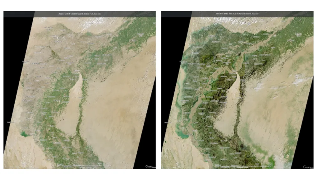
Sentinel-2 images of southern Pakistan on 12 July 2022 and 31 August 2022, showing the extend of the flooded area. © Contains modified Copernicus Sentinel data (2022), processed by Novaspace
The value of these observations extends beyond identifying where flooding occurred. Repeated satellite coverage can help authorities compare conditions over time, prioritize areas for further assessment, and plan recovery in locations where ground access is limited. The effectiveness of that information still depends on its integration with field reporting and operational decision-making.
Wildfire monitoring shows the value of complementary capabilities
Satellite observations also support wildfire monitoring by identifying thermal anomalies, smoke plumes, and changes in vegetation. Optical and thermal data provide broad-area awareness, while drones and ground observations can help validate hotspots and refine assessments of fire perimeters. Used together, these sources offer a more complete picture than any single technology alone.
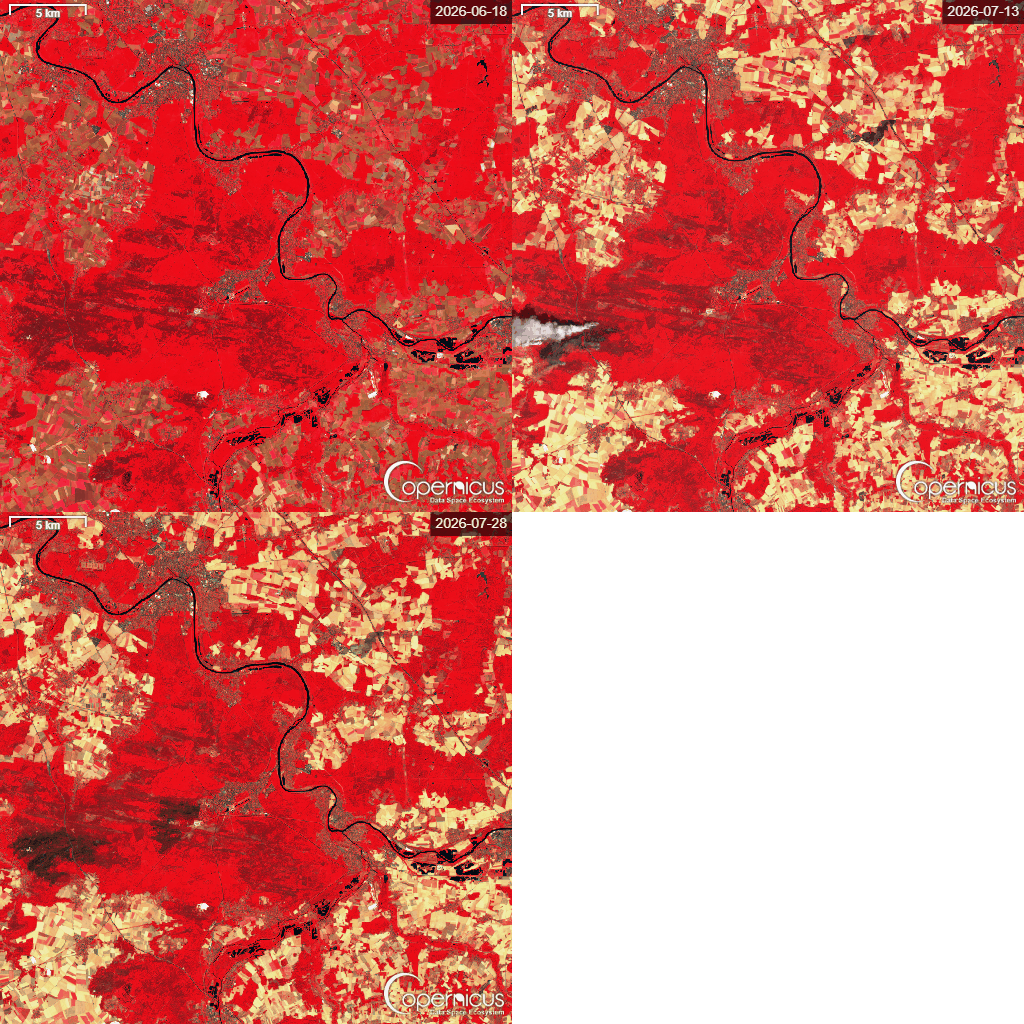
False-color Sentinel-2 imagery illustrating vegetation changes associated with the July 2026 Fontainebleau forest fire. © Contains modified Copernicus Sentinel data (2026), processed by Novaspace.
The combination of space-based monitoring, local validation, and reliable communications is particularly important when emergency teams must operate under rapidly changing conditions. Satellite information can help inform response, but it must be delivered in formats and timeframes that match the needs of those coordinating operations on the ground.
A growing role for commercial data and services
Space-enabled disaster management is also evolving as a market. During emergencies, commercial imagery and data are sometimes made available to public organizations on a goodwill basis. Over time, the wider adoption of satellite data in risk models, early warning, and resilience planning may create opportunities for recurring services serving public institutions, insurers, and reinsurers.
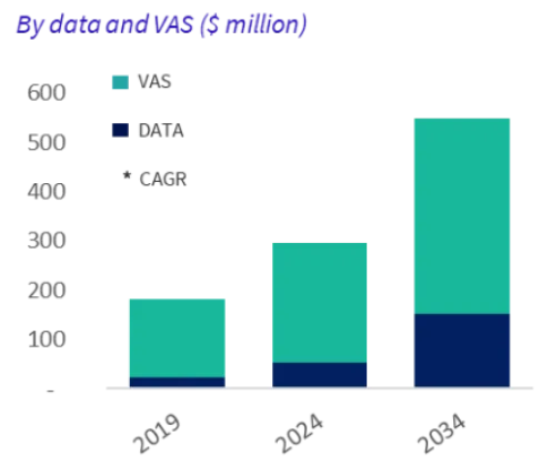
Growth in the commercial market for emergency data and value-added services. Source: Novaspace EO Data &Services report, 2025
This evolution points to a shift from delivering imagery after an event toward providing information that can be incorporated into risk assessment and operational planning before disruption occurs. The opportunity lies not only in collecting data, but also in translating it into usable services for specific decision-makers.
Turning technological capability into resilience
Advances in satellite constellations, analytics, and hybrid architectures can improve the availability and usefulness of space-based information. However, the full benefits depend on coordination among satellite providers, public authorities, emergency responders, and infrastructure operators. Standardized data-sharing protocols, interoperable systems, and joint training are necessary to ensure that information is understood and used effectively.
The central challenge is therefore operational integration. Space technologies already contribute to every stage of disaster management; their next step is to become a more consistent part of the systems and decisions that protect people, infrastructure, and essential services. Turning satellite data into timely action is where their contribution to resilience becomes tangible.
RELATED DISCUSSION | Space Summit for a Resilient Future (SSRF), Toulouse, October 27–28, 2026.